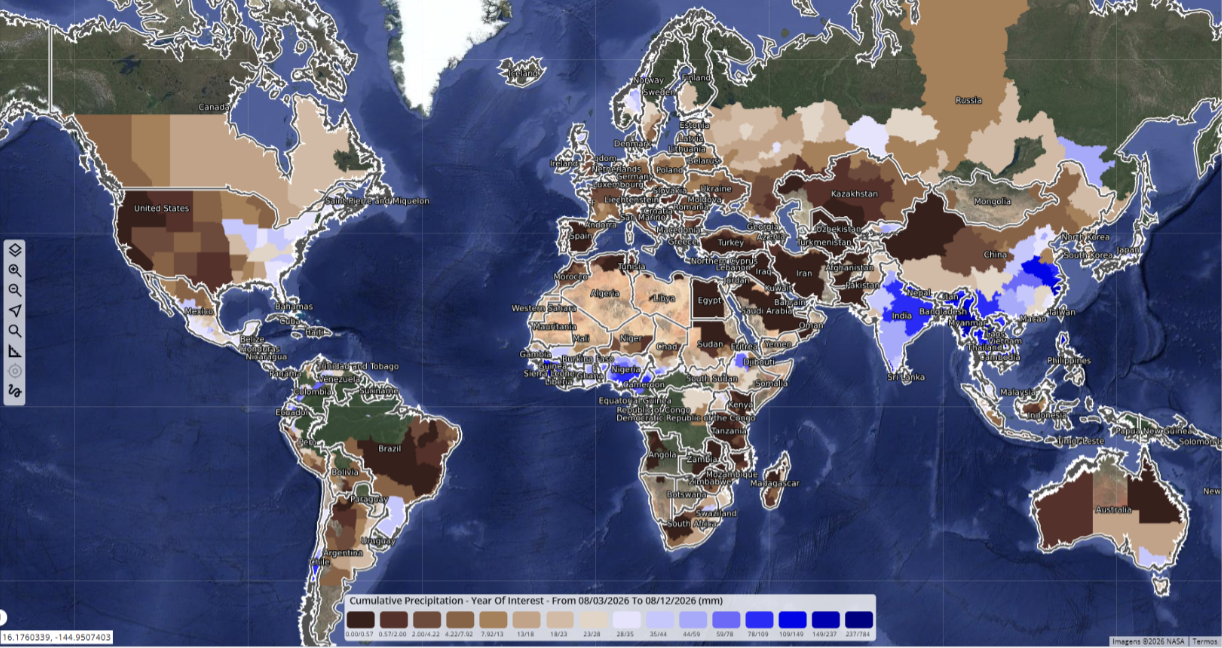
Across major farming regions, crop conditions are shifting quickly as rainfall and temperature patterns become more uneven. Too much rain is creating problems in some places, while others are dealing with persistent dryness.
>>>READ: Natural Biopesticides Could Help Farmers Avoid Residue Limits and Reduce Food Waste
One factor shaping that volatility is the strengthening El Niño, a periodic warming of the tropical Pacific that can alter weather patterns around the world. The World Meteorological Organization expects the current event to intensify through August-October, overlapping with important stages of crop development in several major producing regions.
The crop picture is already diverging sharply. Southern Brazil is dealing with excessive rainfall, while parts of India remain unusually dry.
Knowing El Niño is present still leaves the agricultural question unanswered: what does it mean for a wheat crop in Paraná or a maize field in northeast India at this point in the season? Answering that requires following the crop as conditions change.
July showed how quickly that picture can move. Canadian crops held up through hotter, drier weather, rain improved Argentina’s wheat outlook, and European corn deteriorated during flowering, all within a few weeks.
Weather and crop forecasting have always been closely linked. As weather patterns become more volatile, that relationship is getting tighter and faster. Increasingly, the challenge is knowing which indicator matters at a particular point in the season and what it is actually saying about the crop.
The Signal Changes as the Season Moves
Rainfall is an obvious place to start. It is also easy to misread in isolation. Which signal matters shifts as a crop moves through its own calendar, and the Canadian Prairies show why.
The region dried out in July and soil moisture fell, yet crop conditions remained strong, helped by heavy rain in May and June that had already built moisture reserves. By late July, Reuters reported that Prairie crops were in their best mid-season condition in about a decade, based on EarthDaily’s analysis of satellite and agronomic data. A rainfall deficit in July carried a very different implication than it would have after a dry spring.
As crops move through flowering and grain filling, when kernels are developing and gaining weight, temperature and short periods of moisture stress become more important. Later, excessive rainfall can raise disease pressure, delay fieldwork or affect grain quality even when vegetation still looks healthy.
Southern Brazil illustrates that last point. The region remained wet through July, with moisture increasing further in Paraná. For wheat, the question now is how long that pattern persists as the crop develops.
A national map showing where rainfall is above or below normal may tell us where to pay attention. Soil moisture, vegetation condition and crop stage help tell us whether the weather is beginning to matter.
In Western Australia, rainfall is beginning to resemble 2023, when yields were poor, although vegetation remains considerably stronger than it was at the same stage that year.
Crop Forecasting Is a Continuously Updated Process
Crop forecasting already draws on weather forecasts, field observations, crop models and official reporting. Satellite observations, automated analysis and increasingly capable AI systems are making it easier to update that picture between formal assessments, tracking rainfall, soil moisture and vegetation performance as conditions change.
Australia also showed how quickly the picture can reverse. In June, the country’s last remaining weak spot, northern New South Wales, was recovering quickly, with satellite measurements of vegetation greenness, commonly known as NDVI, pointing to a strong turnaround. By July, that favorable read had given way to a drier, more uncertain national outlook.
>>>READ: End the Penalty on Prescribed Burns
U.S. spring wheat followed a similar back-and-forth: weaker satellite vegetation readings concentrated in eastern North Dakota in June gave way to a brief improvement, before weakening again in the same area by July. A seasonal outlook may remain valid through those changes. The crop picture underneath it keeps moving.
Scale is part of the challenge. During an event such as El Niño, several major producing regions can change at once. Automation can narrow the search to places where rainfall, moisture or vegetation signals have moved materially, leaving analysts to determine what those changes mean for the crop.
The Right Indicator at the Right Time
Agriculture already has enormous volumes of weather, satellite and crop data. The opportunity now is to connect the pieces that matter at the point when they matter most. Consider India. By early August, national monsoon rainfall was below its historical average, but regional conditions varied sharply. Central India was slightly above average while deficits were much deeper elsewhere.
For maize and soybeans in those drier regions, the national number only goes so far. What matters is whether the shortfall overlaps with the crop areas and development stages where another dry spell could begin to affect performance.
The task is to connect those signals quickly enough to keep pace with the crop. That has implications well beyond yield forecasting. Grain quality, harvest timing and regional availability can change before final production numbers do. Commodity buyers, feed markets, insurers and food-security planners are making decisions while the season is still unfolding. Earlier visibility gives them more room to respond.
That calls for a different approach to agricultural monitoring. Seasonal outlooks are the starting point. Farmers and agribusinesses need crop-condition information that can be updated as the season changes, while policymakers need monitoring systems that bring weather, satellite and field observations together quickly enough to support crop assessments, drought response and food-security planning. For agricultural technology, the priority should be making those signals consistent and usable across large areas, rather than simply adding more data.
El Niño can significantly reshape weather across major agricultural regions, but it rarely acts alone. The Indian Ocean Dipole, another ocean pattern that can shift rainfall across countries around the Indian Ocean, can reinforce or offset El Niño, as can shorter-term weather systems. That is why crop impacts have to be assessed through the conditions developing in each region rather than attributed to El Niño alone.
The next two months will make that especially important. WMO expects El Niño to strengthen through August-October, favoring drier conditions over the Indian subcontinent and southern and eastern Australia, with wetter conditions across parts of southeastern South America.
The global warning is already there. The job now is to see where those weather shifts begin to change crop performance, while there is still time to act.
Felippe Reis is a Crop Analyst at EarthDaily, where he supports crop condition monitoring, yield analysis, and market-relevant agricultural insights.
The views and opinions expressed are those of the author’s and do not necessarily reflect the official policy or position of C3.